PAZ074
There are no active watches, warnings or advisories
| Weather Data for Stahlstown PA | |||
|---|---|---|---|
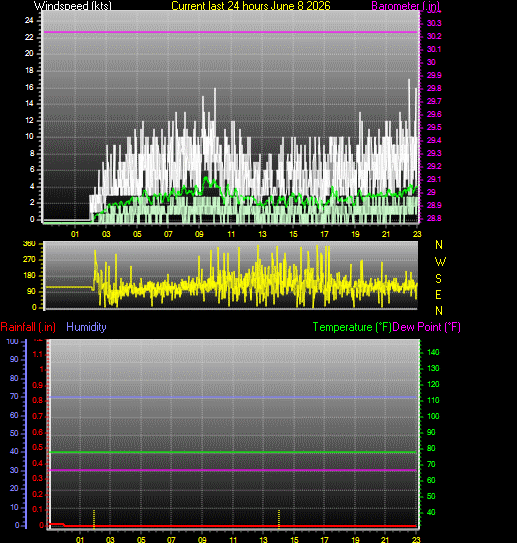
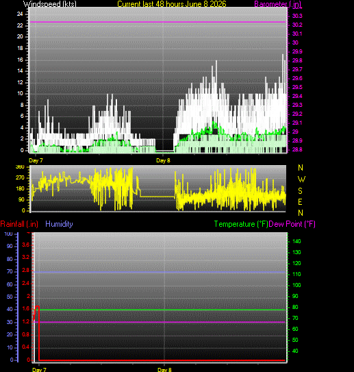
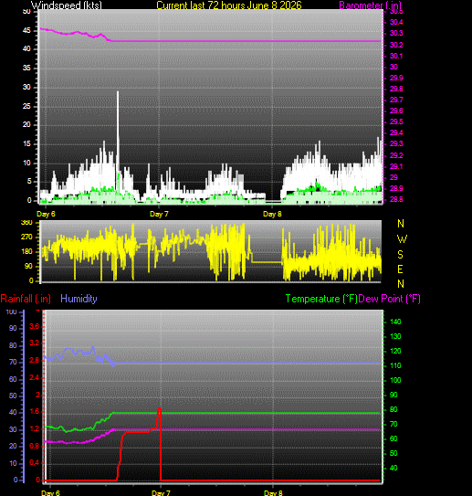
| LAST READING AT TIME: 11:00 PM DATE: June 08 2026, time of next update: 11:05 pm | |||
| Current Weather | Dry | Current Temperature | 67.7°F (19.8°C) (Heat Index 67.7°F ), Apparent temp 63.4°F |
| Maximum Temperature (since midnight) | -148.0°F at: | Minimum Temperature (since midnight) | 61.0°F at: 2:20 AM |
| Average windspeed (ten minute) | 4.6 kts (8.5 kmh) | Wind Direction (ten minute) | ESE (113°) |
| Windchill Temperature | 67.7°F | Maximum Gust (last hour) | 17.4 kts (32.2 kmh) at: 10:30 PM |
| Maximum Gust (since midnight) | 17.4 kts (32.2 kmh) at: 10:30 PM | Maximum 1 minute average (since midnight) | 7.8 kts (14.5 kmh) at: 10:30 PM |
| Rainfall (last hour) | 0.00 in. (0.0 mm) | Rainfall (since midnight) | 0.00 in. (0.0 mm) --- |
| Rainfall This month | 1.71 in. (43.4 mm) | Rainfall To date this year | 19.45 in. (494.0 mm) |
| Maximum rain per minute (last hour) | 0.00 in/min | Maximum rain per hour (last 6 hours) | 0.00 in/hour |
| Yesterdays rainfall | 0.01 in | DewPoint | 32.0°F (Wet Bulb :51.9°F ) |
| Humidity | 83 %, Humidex 63.8°F | Barometer corrected to msl | 30.518 in. (1033.5 hPa) |
| Pressure change | 0.00 in. (last hour) | Trend (last hour) | STEADY |
| Pressure change (last 12 hours) | +0.00 in | Pressure change (last 6 hours) | +0.00 in |
Expires:202606090800;;413928
FPUS51 KPBZ 090003
ZFPPBZ

Zone Forecast Product
National Weather Service Pittsburgh PA
802 PM EDT Mon Jun 8 2026


PAZ074-090800-
Higher Elevations of Westmoreland-
Including the cities of Ligonier and Donegal
802 PM EDT Mon Jun 8 2026

.REST OF TONIGHT...Mostly cloudy. Lows in the lower 60s.
Southeast winds 5 to 10 mph with gusts up to 25 mph.
.TUESDAY...Mostly cloudy. A chance of showers and thunderstorms
in the afternoon. Some thunderstorms may produce heavy rainfall
in the afternoon. Highs in the mid 80s. South winds 5 to 10 mph.
Chance of rain 50 percent.
.TUESDAY NIGHT...Showers. Scattered thunderstorms. Some
thunderstorms may produce heavy rainfall. Humid with lows in the
mid 60s. South winds 5 to 10 mph with gusts up to 25 mph. Chance
of rain near 100 percent.
.WEDNESDAY...Showers. Isolated thunderstorms in the morning, then
scattered thunderstorms in the afternoon. Humid with highs in the
lower 80s. Southwest winds 10 to 15 mph with gusts up to 25 mph.
Chance of rain 90 percent.
.WEDNESDAY NIGHT...Scattered thunderstorms. Showers with lows in
the upper 60s. Southwest winds 5 to 10 mph with gusts up to
25 mph. Chance of rain 90 percent.
.THURSDAY...Partly sunny with scattered showers in the morning,
then mostly cloudy with numerous showers and thunderstorms in the
afternoon. Highs in the upper 80s. Chance of rain 70 percent.
Heat index values in the mid 90s in the afternoon.
.THURSDAY NIGHT...Mostly cloudy. Numerous showers and
thunderstorms, mainly in the evening. Lows in the upper 60s.
Chance of rain 70 percent.
.FRIDAY...Partly sunny in the morning, then becoming cloudy. A
chance of thunderstorms. A chance of showers in the morning, then
showers in the afternoon. Highs in the mid 80s. Chance of rain
90 percent.
.FRIDAY NIGHT...Mostly cloudy with a chance of thunderstorms.
Showers, mainly in the evening. Lows in the lower 60s. Chance of
rain 90 percent.
.SATURDAY...Mostly sunny. Highs in the lower 80s.
.SATURDAY NIGHT...Mainly clear. Lows in the lower 60s.
.SUNDAY...Partly cloudy in the morning, then partly sunny with a
chance of showers and thunderstorms in the afternoon. Highs in
the lower 80s. Chance of rain 50 percent.
.SUNDAY NIGHT...A chance of thunderstorms in the evening. Mostly
cloudy with a chance of showers. Lows in the upper 50s. Chance of
rain 50 percent.
.MONDAY...Partly sunny with a chance of showers. Highs in the
upper 70s. Chance of rain 50 percent.

$$